[title subtitle=”words & images:Jim Warnock”][/title]
At one time, I resented the drive to hiking locations. It felt like lost time, sitting behind a steering wheel instead of hiking the trail. Gradually I came to see beauty and interests along the roadsides of the Arkansas Ozarks. The character and tenacity of the people are evident in the structures they built. Their personalities are in the stories they left behind, or the silent witness of the stones they assembled.
Here are just a few of my favorite places to eat, photograph and hike along Ozark roads.
Mountainburg Cabins
I drive through Mountainburg in route to many trailheads, but only recently noticed these little cabins, last used in the late 1960s. They are a short distance off of AR 71 at the turnoff that led to the original Lake Fort Smith State Park, which closed in 2002 when the lake was expanded.
The Dairy Dream
The Dairy Dream is a little farther south on the east side of AR 71 in Mountainburg. Built in 1955 by Bob Willroth, the Dairy Dream sold “Mountainburgers” for twenty-five cents and ice cream cones for a nickel. Mountainburg local Brad Birchfield said, “I highly recommend a Mountainburger with cheese. You’ll be hooked!” I look forward to having a “Mountainburger” at today’s price of $2.50 after my next hike on Shepherd Springs Loop at Lake Fort Smith State Park.
Artist Point
Artist Point, north of Mountainburg, is one of my favorite places on AR 71. In 2001, this was one of our first stops when we were considering moving to the area. A helpful young lady was working behind the counter as her grandparents looked on. Her little brother was also behind the counter. I asked where they went to school, and in unison they said, “Alma.” They later learned I was their new school principal. It was a pleasure to watch them grow under the love and stability of their parents and grandparents.
Stop by and look out over the valley for some breathtaking views—there are several spots where you can see for miles. Day hikes in the area include Shepherd Springs Loop at Lake Fort Smith State Park. A little farther north is the Yellow Rock Trail at Devil’s Den State Park.
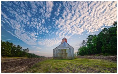
Barn on Hwy 23
Old structures along the roads sometimes cause me to pull over to get a better look. I’ll grab my camera and explore a while. This barn on Highway 23 south of Cass is beautiful in every season.
Rock House
Want to take a short break from your drive and get a good workout? Hike the 0.5-mile round-trip west of the Cherry Bend Trailhead on AR 23 to what backpackers call the Rock House. Be careful as you cross the highway and don’t let the short distance deceive you. It’s a tough climb to the Rock House.
Area loggers probably built this shelter sometime during the 1890s to 1920s. White oak was heavily logged to make railroad ties for the nation’s expanding railroad system. There is a small, seasonal spring at the base of the bluff inside the Rock House. A Methodist circuit preacher used the Rock House during the late 1920s and possibly into the early 1930s. The popular Cherry Bend Trailhead accesses the Ozark Highlands Trail five miles north of Cass.
The area includes the Redding Loop Trail and Hare Mountain access on the Ozark Highlands Trail. The Ozark Highlands Trail has several access points along AR 215. One of the best hikes in the state, beginning at the Indian Creek Canoe Launch, is the Dawna Robinson Spur Trail to the Marinoni Scenic Area.
Turner Bend
Popular among hikers and Mulberry River floaters, the Turner Bend Store has great sandwiches served up by good people. They’re located on Highway 23 close to Cass. Stopping there is always a treat!
The Oark General Store and Cafe
The Oark General Store, known for being Arkansas’ oldest continuously open restaurant, serves up a good breakfast, lunch, and dinner. It’s a necessary stop if you’re hitting the western part of the Ozark Highlands Trail. Oark is a short drive south from the Arbaugh Trailhead. To get to the Oark General Store, go to Oark.
Catalpa Café
Be sure to stop at the Catalpa Café for a true backwoods dining experience. On a recent visit, I ordered the lunch special (pork loin, mashed potatoes, mixed vegetables and a roll). The owner, waiter, and chef were one in the same and served up a good meal and good conversation.
A mother and daughter seated close by ordered cheeseburgers that were hand-formed and grilled fresh. They enjoyed studying the Ozark Highlands Trail map hanging on the wall. The owner said it was the first map he’d ever seen that showed Catalpa. As I drove away, I could have sworn I saw the Duck Dynasty brothers just down the street.
To get to the Catalpa Café, drive east of Oark on AR 215 for about three miles. When you enter Catalpa, watch for a sign directing you onto Main Street. The Catalpa Café will be on your right.
Burger Barn
If you’re coming off of the Ozark Highlands Trail at the Ozone Trailhead, you’ll want to have a hamburger and fries at an open-air picnic table under an awning at the Burger Barn. Located on Highway 21 in Ozone, it is an Arkansas original and well known within the backpacking community.
Hagarville Grocery Store
The Hagarville Grocery Store is a great little stop on AR 215 north of Clarksville. The owner runs shuttles for hikers when needed and usually has some good trail stories to share. The beautiful Hurricane Wilderness Area of the Ozark Highlands Trail is a challenging and nationally known backpacking trail in the area.
Hankins Country Store
Another favorite stop on the road to the trails is Hankins Country Store, located at the intersection of Scenic Highway 7 and AR 215. An old post office and several interesting old items are inside. There’s even a barber’s chair that is used from time to time if someone needs a haircut. The wood-burning stove feels great after a winter hike at Pedestal Rocks or the Hurricane Wilderness Area. They also make a good sandwich, especially after a long hike!
I try to keep the ratio of miles driving to hiking at a reasonable level. Driving one hundred miles to hike two is a poor ratio. Driving forty miles to hike seven is a respectable ratio and easily accomplished in Arkansas.
These days I enjoy the drive, and I’m thankful for the blacktop and gravel roads that lead to dirt and stone footpaths. It’s all part of the larger scene: the back roads, the people, and the trails that trace the paths of their lives.
Ozark Highlands Trail Boston Mountains, West by Underwood Geographics – A detailed map of the Ozark Highlands Trail that includes connecting roads and several points of interest mentioned in this article.
Arkansas’ Mulberry River by Underwood Geographics – A map of the Mulberry River that covers some of the points of interest in the area.
Ozark Highlands Trail Guide by Tim Ernst
Jim Warnock’s blog: OzarkMountainHiker.com