[title subtitle=”WORDS Dwain Hebda
IMAGE courtesy Debbie Doss”][/title]
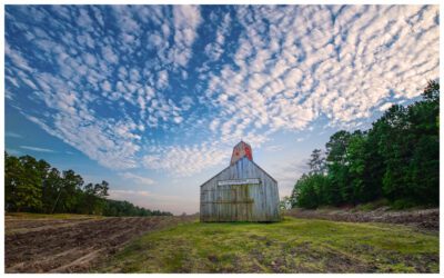
Debbie Doss lifts the paddle head out of the latte-colored water and lets it rest on the kayak. Her bright vessel drifts smoothly, deliberately, like a horse let off its lead, past gargantuan trees in the flooded timber of Bayou DeView. Overhead, the azure sky is spattered with overhanging tree branches, grating the light into shards while echoing bird calls emote from every direction.
Debbie has paddled this route hundreds of times, but still, the sight of the place, the Sistine Chapel of the Arkansas Water Trails, never fails to take her breath away.
“Nature is my only religion, and the outdoors is my only church,” Debbie told me. “DeView is a very sacred one.”
If you’ve ever wondered what primeval looks like, you’ll find it on the Arkansas Water Trails, paddling routes that deliver a mind-bending view of The Natural State. It’s a scene you experience visually and viscerally – at once astonishing in its age and beauty and terrifying in its sheer size and mystery.
The mind plays tricks here as the chocolate water swirls and the silence overpowers you amid grove after grove of trees – cypress, tupelo, and various water-loving oaks. The oldest of them are easily 900 years old if that tells you anything. Put into context, Christian Europeans were still waging Crusades in the Holy Land when these ancients were saplings.
“All of the trails have their own characteristics, and each one is different and unique in its own way,” Debbie says. “Some of them are more open and some of them, like DeView, are actually a river, so you do have current. It’s generally slow-moving, but you do have current.”
“At Grassy Lake, which is near Mayflower, it’s a green tree reservoir, which also has cypress. But there’s really no current at all because it’s an impoundment. You still need the trail because you’re still going through a whole lot of flooded timber and stuff.”
There is literally no other place in the state quite like the marshy, swampy environs of the Arkansas Water Trails. Designated by the Arkansas Game and Fish Commission and currently numbering fourteen statewide, these trails give paddlers an up-close view of time frozen in place, by turn majestic, eerie, natural and alien. The visitor is just one of a cast of thousands here, among the birds, insects, fish, frogs, turtles and who-knows-what sliding and slithering under groves of lily pads and around the bases of trees.
“We’ve got other places, like down at Arkansas Post, where it’s more marshy and open and where you can see alligators and things like that,” grins Debbie, who never met a reptile she didn’t like. “Generally, they go the other way.”
The Arkansas Water Trails can be found throughout the southern half of the state, with additional trails as far north as Marion and Poinsett counties. More are being considered for inclusion in the state’s collection and even more are waiting to be discovered.
“There’s a lot of places to paddle that are just great that are not yet official water trails,” Debbie says. “I’m working with the Game and Fish Commission on some, which all seem to be in the eastern part of the state right now. We’re working with one called Wapanocca over close to Memphis that is a nice little lake paddle that we’re going to add to the state water trails.”
“We’re also looking at places to paddle up on the Black River, which comes out of Missouri on the eastern side of the state and joins the White River near Newport. And in the southwest and western part of the state, Sulphur River is one that people should check out.”
If the system has patron saints, it’s undoubtedly Debbie and her husband Cowper Chadbourn, who have been crucial activists for creating the trails and overseeing certain routes. Following the spring 2021 snowstorm, they paddled the most popular trails to check for damage and inspect the reflectors and signage nailed to trees that mark paddlers’ route.
“They’re all in pretty good shape now,” she says. “We checked out the main ones that get the most use here in Central Arkansas, which is Grassy Lake and Bayou DeView and Wattensaw Bayou. Those are all good to go.”
“Over the years as people have gotten used to the trails, we’ve had fewer issues with sign removal. We still get some a little bit every year during hunting season. There’s some competition to get out to the duck holes and people will sometimes take signs down. But we always go out after the season’s over, just to make sure that you can still find your way around the trails without any problems. Everything is looking pretty good, so far. We’re ready for spring.”
Arkansas’ Water Trails represent some of the last remaining enclaves of Arkansas wilderness. Once covering as much as a third of the state, these ecosystems were fed by seasonal flooding of the Mississippi River, blessing Arkansas with some of the richest soils on earth. However, this very flooding made large-scale cultivation impossible in many areas and so began a decades-long effort to tame the land for habitation and agriculture.
Over time technology allowed that very thing to occur, with state and federally funded reclamation programs. Arkansas gained millions of acres of rich farmland at the expense of the flood-flush-fortify system that helped create and nourish it in the first place.
Bayou DeView, and places like it, might have disappeared altogether were it not for a battery of conservation groups – Arkansas Game and Fish Commission, The Nature Conservancy, Arkansas Natural Heritage Commission and others – that have worked to bring them under protection.
Debbie has gone so far as to found the Arkansas Water Trails Partnership to promote and protect these untamed spaces, providing benefits for generations. The group works with various partners to develop public paddling trails throughout the state, creating well-mapped accessible day and overnight trips in a variety of settings and for all levels of paddling experience.
“It’s a perfect thing for a novice just learning to paddle,” she says. “There are certain things you still need to learn just for safety, but as far as skills in the boat, people with rudimentary skills can get out there and do just as much as anybody else. Adrenaline is the attraction for whitewater sports, but this is endorphins and serotonin. It’s a place where you can go and be enclosed by a natural experience.”
Adventure Awaits
The Arkansas Water Trails includes 14 routes, each with its own flavor and mood.
Arkansas Post Water Trail (Arkansas County)
Bayou Bartholomew Water Trail (Ashley, Jefferson, Lincoln counties)
Bayou DeView Water Trail (Monroe County)*
Crooked Creek Water Trail (Marion County)
Cut-Off Creek Water Trail (Drew County)
Felsenthal National Wildlife Refuge Water Trails (Union and Ashley Counties)*
Grassy Lake Water Trail (Faulkner County)*
H Lake Water Trail (Arkansas County)
Islets Cove Paddle Trail on DeGray Lake (Clark County)
Lake Ouachita | Rabbit Tail Water Trail (Garland and Montgomery counties)
Little Maumelle River Water Trail (Pulaski County)*
Robe Bayou Water Trail (Monroe County)
St. Francis Sunken Lands Water Trail (Poinsett County)
Wattensaw Bayou Water Trail (Prairie County)*
* Arkansas Water Trails Partnership Trail
To learn more:
Arkansas Game and Fish Commission: agfc.com/en/explore-outdoors/wildlife-viewing/water-trails/
Arkansas Water Trails Partnership: arkansaswatertrails.com